sfakia-crete.com (c) 2004. Hotel Stavris Sfakia: rented rooms, apartments, studios, Crete, Kreta.

Taverna Three Brothers, Chora Sfakion: Rent Rooms, Studios and Apartments

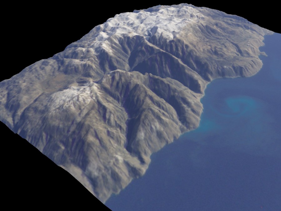
3D views of the White Mountains/ Lefka Ori

English version  Nederlandse versie

by Steve Crow - UK

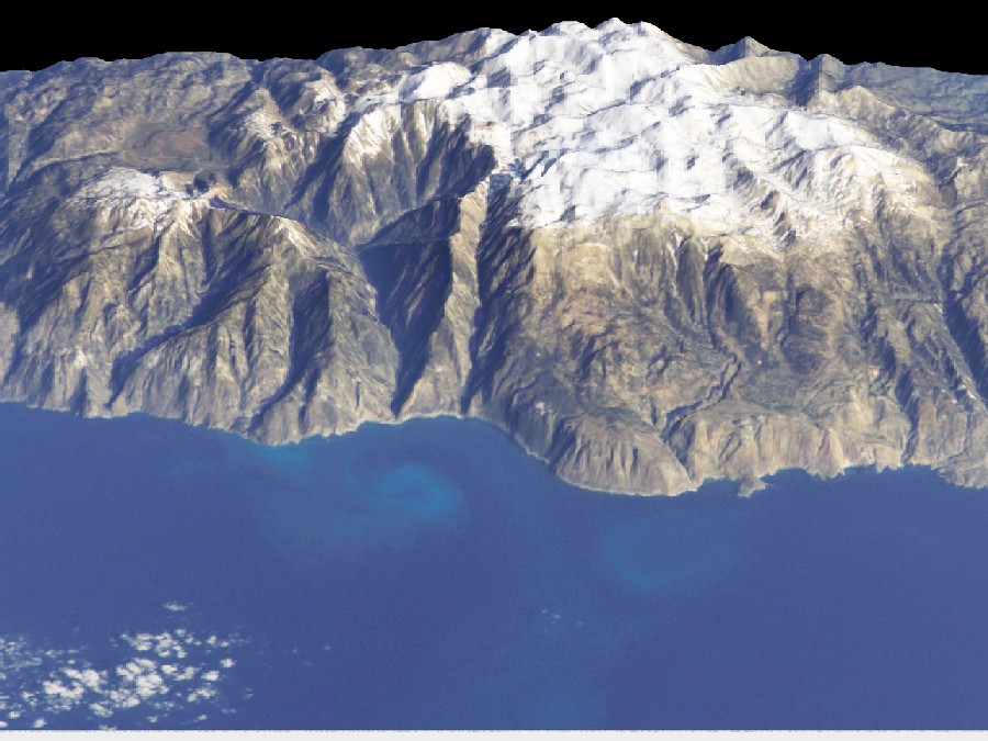
These 3D views of the Lefka Ori were rendered using a program called TERRAGEN - a freeware terrain generator.


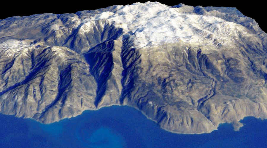
The Lefka Ori - White Mountains - West Crete
click picture for full size

First of all, the contour lines of a Harms Verlag 1:100,000 map were manually traced and digitised to produce a Digital Elevation Model (DEM) of the area.

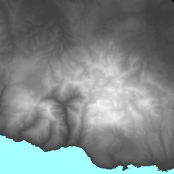
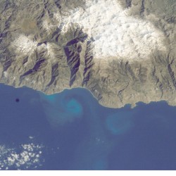
The DEM was then deformed (rotated, resized and stretched) until it lined up and matched with part of a satellite image of West Crete available from NASA.

The DEM was then opened in TERRAGEN and the satellite image "draped" over it.

Once this is done the terrain can be viewed from any angle.
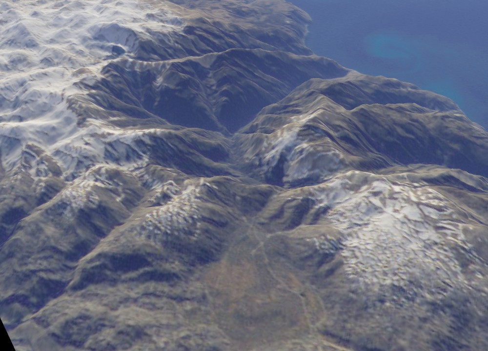

View from the South East
click picture for full size


Above Omalos
click picture for full size


Above Kastro
click picture for full size

The terrain can also be exaggerated vertically and the lighting changed.


With Vertical Exaggeration
click picture for full size

There are a couple of problems with all these views.

Firstly if you look there are two Aradena gorges running parallel with each other. This is because I couldn't get the underlying terrain to exactly match the satellite photo.

Secondly the peak of Gingilos is missing! This is because the Harms Verlag 1:100,000 map I used to digitise the contours has left out 5 or 6 contour lines at the peak. I've seen this omission on other maps as well.

Can you help me?

I can improve these views and sharpen up the definition of the terrain if I could only get my hands on better maps. German WW2 1:25,000 invasion maps are very good and obviously out of copyright. Also US Army (1:50,000 10 meter contours) exist, I have seen the index and have the sheet number but have never actually seen one. I have also seen small section of Greek Cyrillic maps with 20m contours.

Maps with bathymetric information (sea depth) would also be useful as I could show underwater terrain.

If anyone has any scans or sources of maps, Arial/satellite photos this would help me a great deal. Even fragments of maps would be useful as these would help me add local detail.

Also does anyone know of a program (preferably freeware) which will deform an image to match another?

Thanks in advance.

Steve Crow | e-mail

Custom Search

Links and sources

TERRAGEN

NASA


holiday accommodations in Sfakia, Crete: hotel, rooms, studios, apartments, hire cars/ rent car
Our selection of family run holiday accommodations
in Sfakia, southwest coast Crete

Hotels, Rooms, Studios, Apartments, Car hire, Taxi


WHAT'S NEW ABOUT SFAKIA and CRETE:
Practical information for visitors to Sfakia
uk deutsch Nederlands
Ferry timetables southwest coast 2009
hand Bettina's Current Photo Report from Sfakia 2010
Crete-Kreta-Kriti.com: Cretan links
General Links | Accommodation Links
Airports Crete: arrivals and departures 2010
Photos Around Sfakia October 2009 by Henk
hand Photos Around Sfakia October 2009 by Wiltrud
Photos Around Sfakia July-August 2009 by Angelika
Photos Around Loutro October 2009 by Janni
Photos Around Loutro July 2009 by Valerie
Large photo Samaria gorge June 2009 by Willem
hand Walks and hikes in Sfakia: an overview
The Monuments of Sfakia by Yorgos
Around West Crete Photos June 2009 by Willem
All web sites of Chora Sfakion
hand Photos Underwater World of Sfakia by Damoulis
Photos Southwest Coast Mountains 2009 by Michael
GPS Maps of Crete and Greece 2009
Greek and Cretan Easter and Christmas Customs
Searching 100 churches in Chora Sfakion by Yorgos
Where the name Sfakia comes from? by Yorgos
New Books about Sfakia, Crete
3D Views of the White Mountains by Steve
Two mountain walks in Sfakia June 2008 by Colin
Panorama Photos by Patrick
Submit your own Cretan Holiday Pictures
Wolfgang Kistler's Sfakia Picture Gallery
The Olive Tree and Olive Oil
Spring flowers in April 2007 by Wiltrud Walk to Mount Gingilos 2007 by Herre
Maps of Crete and the region of Sfakia Pictures of Frangokastello
Pachnes Summit Panorama Map by Steve Paleochora Photos by Fabrice
History of Crete Sfakia 1968 - 2003 france swiss documentary by Jean-Jacques
Greek Name Days Listing: Calendar and Alphabetical Sfakia and Crete Picture Galleries > 4100 photos
Gavdos island Photos by Steve Statistics Incoming Tourists Greece
Mountain Hiking Photos Sfakia Nov 2005 by Ian Diloti - Greek Card Game
Birding Report Frangokastello Nov 2005
Pictures of Sfakia 1 - 2 - 3 Oct 2005
Greece's position in the European Union -
compared with 13 other countries
Interactive Satellite Map of Crete How the Cretan Gorges were formed
3D Satellite Images of Crete Over 1700 links to Cretan web sites
4 Large Maps of Crete - road map Crete Top 100 Cretan Travel Sites
Raki - Tsikoudia : The Cretan Spirit Winter in Sfakia Photo Reports 2002 - 2003
Sfakian Dialect by Peter Herbs and spices of Crete
Winds of Crete The Sphakia Survey: archaeological project
Old Slides of Sfakia 1987 - 1989 Sfakia People and the Dorians
Social and cultural comparison
of Greece and other European countries
Map of the village of Chora Sfakion / Khóra Sfakíon
City maps of Chania - Rethymno - Heraklion
Tavli - Greece's National Game Pictures of Samaria Gorge and Imbros Gorge

< Back to Main Page


unique visitors to this Cretan website since April 21, 1999

Last update: 25 January, 2009 .

Copyright © World2C ™ Multimedia 1999 - 2010. All rights reserved.


Recommend this page to a friend