


What can you do in Sfakia and Crete?
Activities during your holidays in Sfakia, Crete
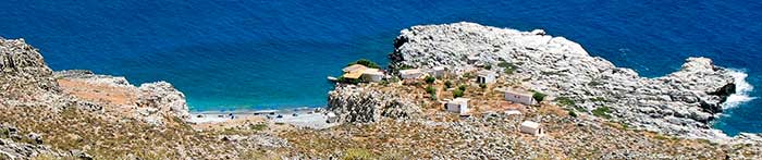
Aradena bridge from the gorge
Sfakia has a rich and varied landscape and culture, and there is really something for everyone to find.
Whether you just want to relax, and stay on one of the many beaches, enjoying the sun and the crystal clear blue sea, or want to go around, to explore Sfakia's nature, or visit the small villages, there is always something to do.
In and around the village everything is on walking distance, or you can take the ferry boat to go a bit more far, or take a taxi boat to visit some more remote, but even more spectacular beaches. If you like hiking, there is plenty opportunity to start walking from Chora Sfakion on the many routes available through the mountains and the gorges. With a locally available hire car you can extend your horizon, and pay a visit to the wider region, and to the historical cities in the north, like Venetian Chania and Rethymno. By public bus you can go either to the nearby villages, or to the north. The ever present sea offers a beautiful environment for swimming, snorkeling and diving, with courses and trips available at the local diving school. You can also book a fishing cruise on a traditional fishing boat, and make your fist catch. There are yoga classes available, and you can explore the many ancient chapels, churches and archaeological sites.
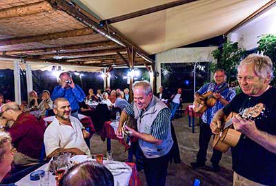
The local tavernas offer a broad choice of local and international plates, to enjoy your lunch at the seaside, or have an entertaining dinner in the night.
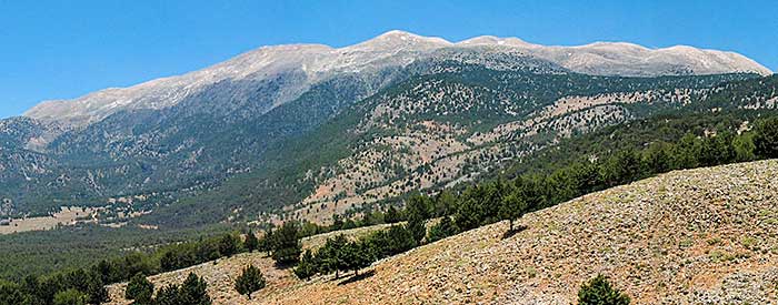
White Mountains, Sfakia
Beaches
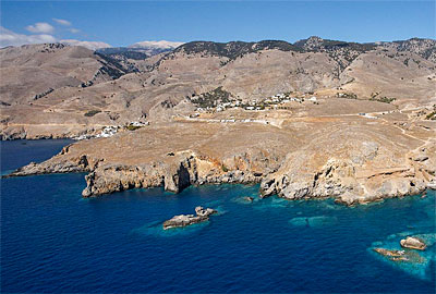
The natural beaches in and around Sfakia are numerous and quiet, and the sea water is the cleanest you can find in Europe. Most beaches are pebbly beaches, but there are also very beautiful sandy beaches, and even sand dunes. It is possible to find your 'own' deserted beach just walking along the coast.
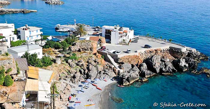
Vrisi beach, the village beach in Chora Sfakion
In Sfakia we recommend:
- • Vrisi Beach : Chora Sfakion village beach (pebbles; rented beds & umbrellas, 70 meters behind Hotel Stavris)
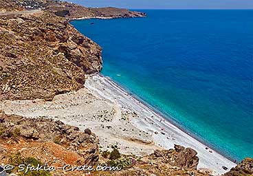
- • Ilingas beach : 1,5 km outside Chora Sfakion (pebbles; taverna; 1 part naturism)
Ilingas beach, Sfakia
- • Filaki beach : 2 km outside Chora Sfakion (pebbles, taverna, naturist beach)
- • Sweet water beach : 15 minutes boat trip or 1 hour walking along coastal
path (pebbles; taverna; camping site; caves; sweet water wells;
boat departure: 10.15, return 17.30)
Sweetwater beach, Sfakia
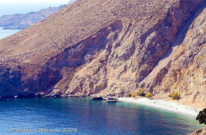
- • Marmara beach : near Loutro
Marmara beach, Sfakia
- • Ammoudi beach : between Chora Sfakion and Filaki beach: follow the path along the small gorge just before Vritomartis Hotel (pebbles; very quiet)
- • Frangokastello beach : down the castle in
Frangokastello (sandy, beds & umbrellas, taverna; sea level
knee deep for 100 metres offshore; ideal beach for kids)
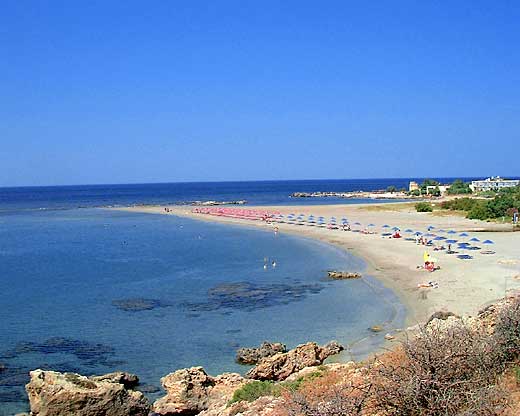
Frangokastello beach, Sfakia
Their are many more secluded beaches to discover along the Sfakian coastline. It is easy to find one just for yourself!
Short walks
If you are interested in shorter walks (1-2 hours), we can recommend the following. Some walks start at your hotel in Chora Sfakion, others can better be accessed by car or bus. Just ask your accommodation owner in Chora Sfakion for directions.
- • In the village of Chora Sfakion are a couple of interesting short walks. From the road that crosses behind the downtown part of the village, you can walk up the path to the cave of Agios Antonios. In the back of the cave you can find a small chapel. The cave is surrounded by archaeological sites: an ancient beehive enclosure and a Roman shrine.
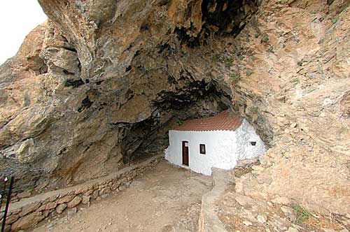
Agios Antonios chapel, Sfakia
- • Above the village you can visit the ruins of the old part of the village in Georgitsi, just uphill.
- • The beautiful path uphill to Manolou is a must-do. You can have a look inside the Ilingas gorge from high up, you pass the old Agia Triada church, and come across archaeological sites with the ruins of a watchtower, and a lime killn. All the time you have a beautiful view of the entire coast.
View from the road to Manolou, Sfakia
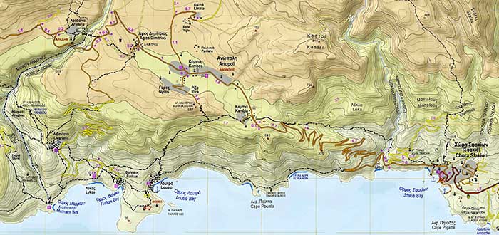
- • Chora Sfakion - Sweetwater beach - Loutro: 2 hrs. 15 min: start at Hotel Stavris, Chora Sfakion, walk up to the asphalt road, follow west bound, pass Ilingas tavern, follow the curve. Just before the road starts it's first sharp curve right up to the mountain, step over the iron protection fence. You see a sign E4, marking the European walking path. It is a path starting from Gibraltar, going through Spain, France, Switzerland, Austria, Hungary, Serbia, Bulgaria and Greece, ending in Crete; it is crossing Crete along its entire length from Elafonisi to Kato Zakros. Follow the rock path down along the coast: this is the beginning of the only ongoing connection between the villages in South West Crete! After 1 hour you reach Sweetwater Beach, which is cliff enclosed: there is a small tavern for drinks. Continue west and you will soon see the picture perfect village of Loutro: a small strip of houses and taverns and hotels around a small harbour. There are no cars here! From here you can take back the ferry to Chora Sfakion, walk back or continue up hill to Anopoli.
- • Chora Sfakion - Anopoli: 2 hrs.: following the old Venitian road to Anopoli (800 meters uphill): just behind Hotel Stavris, take the steps up to the asphalt road, turn left and after about 30 meters you should see a possibility to step up the rocks to your right. After 10 meters the old Venetian road starts, typically with stone walls. The path winds on the hill and goes back into Ilingas gorge. There is a beautiful small bridge here along the cliff slope. Go to the bottom of the gorge and cross it. Don't follow the gorge! On the other side a hollow path takes you uphill, meeting the asphalt road to Anopoli just before the village. This is a very quiet route!
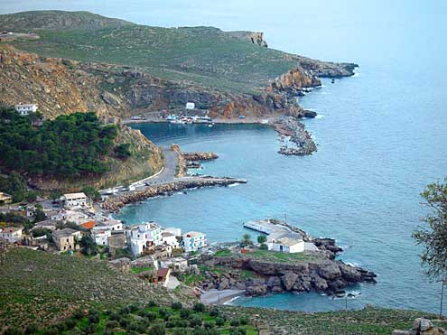
- • Anopoli - Loutro: 1 hr.: from Chora Sfakion follow the 12 km. road up hill (800 m) to Anopoli (bus, taxi). When you see the first buildings, turn left at a small square. Follow the path and continue down hill. All the time you have the magnificent overview of the village of Loutro. Walk back to Chora Sfakion along the coastal path or take back the ferry.
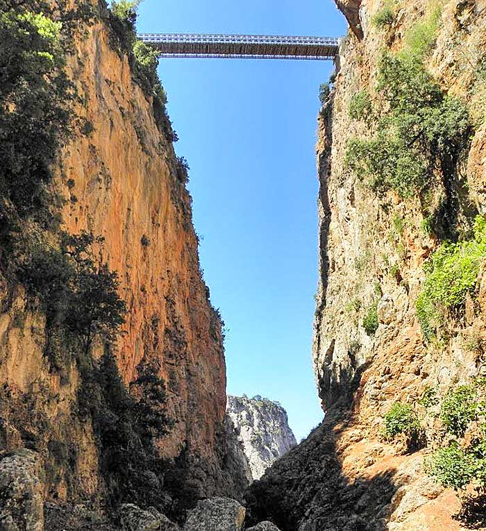
- • Anopoli - Aradena: 1 hr. one way: follow the asphalt road heading north towards the mountains. After 30 minutes you reach the 'real' village of Anopoli, continue from the square with the statue of Daskalogiannis to the north. After a sharp curve to the left you see Aradena Gorge, with a Bailey bridge crossing it. This spectacular view you will never forget again in your life. Cross the bridge to have a look at the deserted village of Aradena. You can also take the old 'road' to Aradena: a little before the bridge to the right you see the old path down the gorge (1 hr.) and on the other side up again (1 hr.)
- • Chora Sfakion - Komitades: 45 min or try to car hike: follow the asphalt road from Chora Sfakion to the east. After 35 minutes at the crossroads, go right. You see the church of Agios Giorgos, with very old frescoes. In Komitades you can take a rest at Taverna Giorgos, the first one to the right. If you like, Giorgos can take you up to Imbros by car, so you can walk the gorge from up to down. Or just fllow the road out of the village and start Imbros gorge from down up (2 hrs.)
- • Komitades - Frangokastello: 2 hrs.: you pass the small villages of Vraskas, Vouvas, Nomikiana, Agios Giorgos, Patsianos. Just before Patsianos there is a T-form crossroads: to the left you go to Patsianos, to the right to Frangokastello. From Patsianos you can make a loop via Skaloti to Frangokastello ( 1 hr.). In Frangokastello you can visit the Venetian fortress, built in 1371.
- • Imbros - Komitades: Imbros Gorge: take from Chora Sfakion the bus to Chania at 7 or 11 o'clock and get out at the village of Imbros. Or take a taxi or ask Giorgos from Komitades if he is available (tel. 28250-91005). When you go by car to Imbros to walk the gorge, please realise you have to walk the gorge both ways: down and up again (2 hrs. one way). Imbros gorge is very beautiful and nature is unharmed here. Wait for the 2 very narrow passages and the natural archway at the end! Imbros gorge used to be the only way to reach Chora Sfakion by the ground, before the asphalt road was built in the sixties.
Gorges
Sfakia got probably its name from the ancient word "Sfax", meaning "Land of gorges". No wonder, since there are about 25 gorges crossing the region, running from north to south across the Lefka Ori mountains to the sea.
Most of them can be walked. Some are very easy, others require quite some hiking experience.
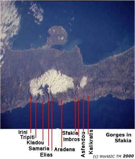
Gorges crossing the Lefka Ori mountains in Sfakia
-
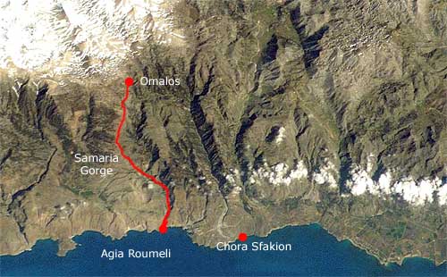
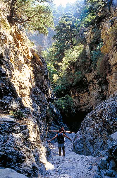
• Samaria Gorge: named after Saint Maria of Egypt. The most famous gorge of Sfakia, Crete and Greece.
You can walk the gorge from top (Omalos) to bottom (Agia Roumeli), or do it the easy way, from bottom to half way up, and then return.
Samaria gorge, Sfakia
• 1) From top to bottom: take the early morning bus from Sfakia to Chania, and from there to Omalos, walk the gorge all the way down to Agia Roumeli, and come bach from there by ferry to Chora Sfakion. You can also take a taxi from Chora Sfakion directly to Omalos, but this is expensive.
• 2) From bottom to half way up: take the morning ferry from Chora Sfakion to Agia Roumeli, walk the gorge up for as far as you like, return to Agia Roumeli, and come back to Chora Sfakion again by ferry.
From top to bottom: Catch the earliest bus from Chania to Xyloskalo to beat the heat and midday crowds. After a scenic 40 km bus ride, you'll be standing high above the wild Gorge of Samaria. Xyloskalo (Omalos) is a small lodge, the end of the road, and the beginning of the trail. The bus will be full of hikers; no one else would come here at this hour. The air is crisp, the fresh blue sky is cool, and most of the gorge has yet to see the sun. Before you lies a 18 km downhill trek, dropping 1400 m through some of the most spectacular scenery anywhere in Greece to a black-sand beach on the south coast. The hike takes four to six hours, the gorge is open from 1st May through October. Descend to the floor of the gorge down an hour of steep switchbacks, and between you and the Libyan Sea on Crete's southern shore are about 12 km of gently sloping downhill trails. There is a hour-long boat ride (or eight-hour hike) to Chora Sfakion, where buses wait to take you back to Chania. If you stay in Chora Sfakion, you can take an early morning taxi to Omalos or the 7 o'clock bus to Chania. Since all buses have left already here, take a taxi to Omalos. Be sure to know what time the last ferry goes from the end of the gorge in Agia Roumeli! Usually this is around 18.00.
- • Aradena Gorge: from Anopoli to Marmara beach, Loutro. A really impressive gorge; it looks like someone cut with a knife through the mountains. However, it's a gorge that needs some experience! It takes 3 hrs from Anopoli and 1hr 15 min from Marmara to Loutro. At Marmara you may ask at the taverna if there is a boat to Loutro. You can also follow the path above the gorge to Livandiana. Some 500 meters before you reach Aradena, the path starts at a sign to the left.
- • Ilingas Gorge: Only for very experienced hikers.
-
• Imbros
Gorge: 7 km, 2 hrs. Starting at the village of Imbros you will
wend your way down the sculpted, pebble-strewn convolutions of the
gorge through the conifers, herbs and flowers. Sheer cliffs tower
above you and butterflies rise and fall in the currents of air. The
Libyan Sea eventually opens out in mesmeric peacock colours before
you and the mysterious island of Gavdos floats there, a stepping-stone
to Africa.
Walking through Imbros gorge, Sfakia
- • Sfakiano gorge
- • Asfendou Gorge: 2,5 hrs. starting from Asfendou. Steep gorge, deep canyon, ending in Agios Nektarios. 20 minutes to the east is a very beautiful and quiet beach, down a dirt road. Ask for directions.
- • Kallikratis gorge
Mountain hikes
For more details: see also are Sfakia walks page.
- • Omalos - Gingilos - Omalos: (5 hours) Gingilos, the impressive mountain that rises vertically above the Samaria gorge is actually quite easy to climb. The view from its summit (2080 m) is one of the best mountain views in Crete. You can see the Libyan sea (to the South) and the Aegean sea (to the North) from the same spot. Those not up to walking to the summit can stop at the spring of Lino Seli or at the saddle below the summit. This mountain can only be climbed when the weather is stable and there are no clouds. As an alternative you can walk to the mountain refuge of Kallergi, which offers a stunning bird's eye view of the Samaria gorge.
- • Aradena gorge: From Marmara beach you can walk up the gorge of Aradena (3 hours) to the abandoned village of the same name. After a tour of the village, walk to Anopolis (40 min.) on a surfaced road then down the old path back to Finix (1 hour).
- • Agia Roumeli - Finix: (5 hours) Follow the coast eastwards past the chapel of Agios Pavlos (Saint Paul is said to have landed here on his journey to Greece) then through a pine forest. The path, high above the coast then offers little shade for the next 2 hours but there is an opportunity to swim at the small beach of Marmara. From there another ½ hour walk brings you to the tiny secluded beach of Finix, just a short walk from the village of Loutro. You may take a boat to Loutro as an alternative to walking. (recommended in high summer because of the heat and lack of shade)
- • Finix - Loutro - Sweet water beach - Chora Sfakion: (2 ½ hours) From the village of Loutro, walk along or above the coast to the spectacular Sweet water beach (drinking water comes out if you dig a hole on the beach) to the village of Chora Sfakion. Little shade but plenty of sea! You may take a boat as an alternative to this walk.
- • Omalos - Kallergi - Melindaou (2153 m) - Katsiveli: (8 hours) This route starts at the entrance of the Samaria gorge. Walk up to the roof of the White Mountains and proceed eastwards, at an altitude of about 2000 m to Katsiveli, at the foot of Pachnes. The night is spent in the open.
- • Katsiveli - Pachnes (optional) - Anopolis - Finix beach: This day will take you through as much changes as you can expect on Crete: first walking a couple of hours through a lunar landscape, then driving endlessly down a rough track on the back of a pickup truck through a pine forest to the plateau of Anopolis. From there walk down to Finix beach (1 hour). It is possible to climb Pachnes (2453 m) on a fairly easy path (about 3 hours return) before driving down to Anopolis
- • Eligas gorge - Agia Roumeli: (8 hours) The densely forested gorge of Eligas is one of the wildest and least known gorge in Western Crete. Though shorter than the Samaria gorge it takes considerably longer to walk through because of the difficult terrain. It reaches the Libyan sea about ½ hour's walk east of Agia Roumeli.
Sightseeing
One of the few roads in Sfakia, from Chora Sfakion up to Anopoli
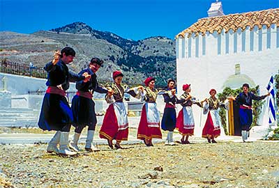
It's a nice activity to look around all the many small villages in Sfakia. Since there are not many roads, they are not all easy to find. But this gives you the opportunity to be really far away of tourism! The local people are very generous and like to welcome 'strangers': this experience will be difficult to forget, joining a family at their table for lunch and have some 'open wine' together. We can recommend the following villages:
- • the Anopoli highland plain, with its villages
- • Komitades
- • the Askyfou highland plain, with its villages
- • Imbros
- • Kallikratis (Janina's wild herbs of Crete shop)
For your sightseeing trips it is a good idea to hire a car.
Car HireBoat trips & fishing cruise
Since in the southwest of Crete there is no ongoing road, most connections from Chora Sfakion to the east and back have to be done by ferries. You can reach the following villages: Loutro, Agia Roumeli, Sougia and Paleochora. In season there is also a connection to the islet of Gavdos, the most southern part of Europe.
You can find the ferry timetable here:
Ferry timetable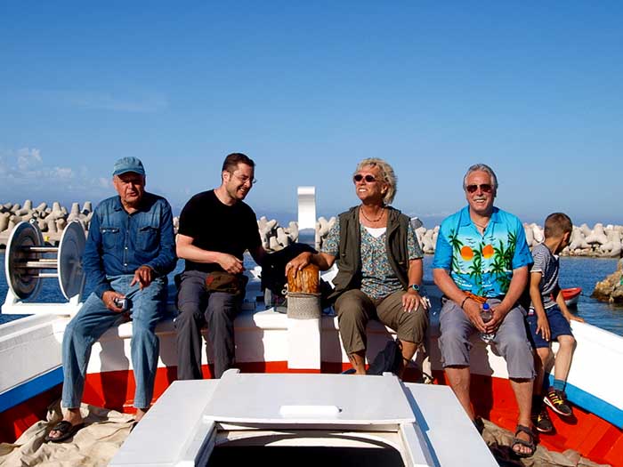
In Chora Sfakion you can join Bettina and Kostas on their fishing boat for a spectacular fishing cruise.
All info can be found here:
Fishing cruises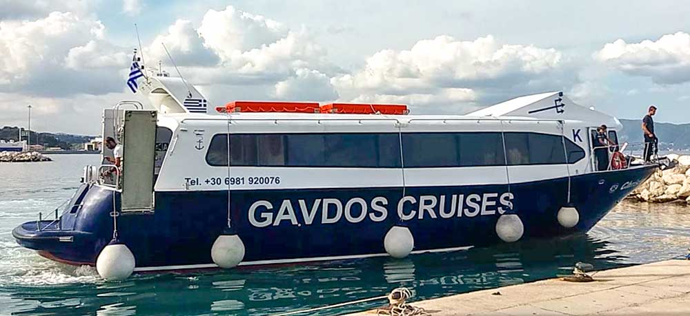
© Photo by Jean Hannah
From end of April, 2016 Gavdos Cruises will start daily boat trips between Chora Sfakion, Loutro and Gavdos island. All information here:
Gavdos Cruises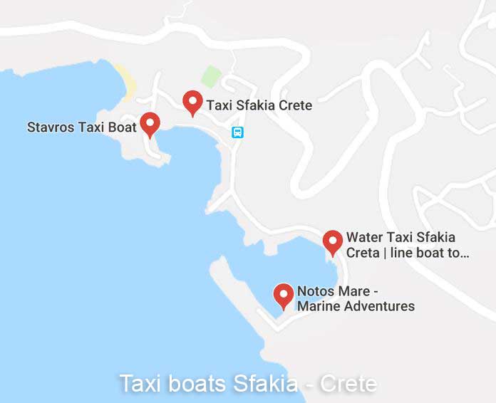
Contact a local taxi boat company for your private taxi boat transfers between Chora Sfakion and Sweetwater Beach, Loutro and Agia Roumeli:
Taxi BoatsArchaeological sites
Sfakia is full of archaeological sites. There are several watchtowers and forts from the Venetian and Turkish era, like the fortresses in Chora Sfakion, Loutro and Agia Roumeli. In Frangokastello you find the spectacular castle from 1371. There are the ruins of ancient cities, and a hundred churches, some of which date back to the late Middle Ages, like the Byzantine church of the Twelve Apostles in Chora Sfakion, or the chapel of Saint Paul at Agios Pavlos beach.
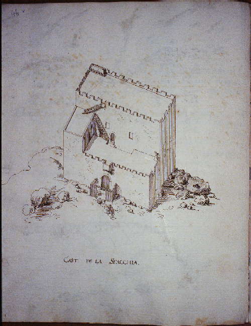
Venetian fortress in Chora Sfakion
To get a good idea of the archaeological finds in the area, have a look at the website of the Sphakia Survey.
The Sphakia Survey is an interdisciplinary archaeological project whose main objective is to reconstruct the sequence of human activity in Sfakia, from the time that people arrived in the area, by ca 3000 BC, until the end of Ottoman rule in AD 1900. Their research covers three major epochs, Prehistoric, Graeco-Roman, and Byzantine-Venetian-Turkish, and has involved the work of many people using environmental, archaeological, documentary, and local information.
Read more:
You can read more news about the history and archaeology of Crete on our
History and Archaeology of Crete Forum
Diving and snorkeling
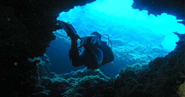
In Chora Sfakion is the Notos Mare diving school. Sfakia is well known for its crystal clear waters with visibility of up to 40 meters. They can offer dives of between 10 to 40 meters deep, at 9 different diving spots, in caves, at cliffs, a reef and a ship wreck. You can find all their information here:
Notos Mare diving clubMuseums in Crete
For an overview of the many beautiful museums in Crete, look here:
Museums in CreteYoga in Sfakia
Chora Sfakion is the ideal place to practice techniques that bring one closer to oneself and others, and help you relax, by connecting with the body and breath. The ancient art and science of yoga is one of these practices that are offered regularly during the summer season. Whether you have never tried yoga before or are an experienced practitioner, Evgenia's classes will add a different dimension of newfound, invigorating relaxation to your holiday.
Read more on Yoga on Crete here:
Yoga in Sfakia